Skip to content
Services et traitements des images aériennes
Twitter Facebook Linkedin
  • Français
  • English
DRONES IMAGING
  • Drones imaging
    • Who are we
  • images processing service
    • topographic service
    • thermographic service
    • agricultural service
    • automatic counting service
    • Use case
    • Product sheets
    • useful documentation
    • download guide
  • Trainings
    • training in photogrammetry metashape option
    • training in photogrammetry Pix4D option
    • Multispectral training
    • online photogrammetry training
  • Softwares
    • Agisoft Metashape photogrammetry software
    • Undet software
  • RTK Receivers
    • EMLID GNSS RTK Reach RS3
    • EMLID GNSS RTK Reach RS2+
    • Emlid GNSS RTK Reach RX
    • EMLID GNSS RTK Reach RS+
  • Sensors
    • Agrowing Multispectral cameras
  • News
  • Contact us
  • Toggle website search
Menu Close
  • Drones imaging
    • Who are we
  • images processing service
    • topographic service
    • thermographic service
    • agricultural service
    • automatic counting service
    • Use case
    • Product sheets
    • useful documentation
    • download guide
  • Trainings
    • training in photogrammetry metashape option
    • training in photogrammetry Pix4D option
    • Multispectral training
    • online photogrammetry training
  • Softwares
    • Agisoft Metashape photogrammetry software
    • Undet software
  • RTK Receivers
    • EMLID GNSS RTK Reach RS3
    • EMLID GNSS RTK Reach RS2+
    • Emlid GNSS RTK Reach RX
    • EMLID GNSS RTK Reach RS+
  • Sensors
    • Agrowing Multispectral cameras
  • News
  • Contact us
  • Toggle website search

Blog

  1. Home>
  2. geomatics>
  3. Inspection of a water tower by drone & cracks detection

Inspection of a water tower by drone & cracks detection

  • June 21, 2017
  • 8:30 pm

Drone inspection & cracks detection onto the walls of a water tower

Drone inspection and photogrammetry: results obtained from 1130 aerial shots taken by the company AirCity Diagnostic. Aerial images analysis and processing service by Drones Imaging.

Drone inspection of the circular wall of a water tower

Inspection par drone

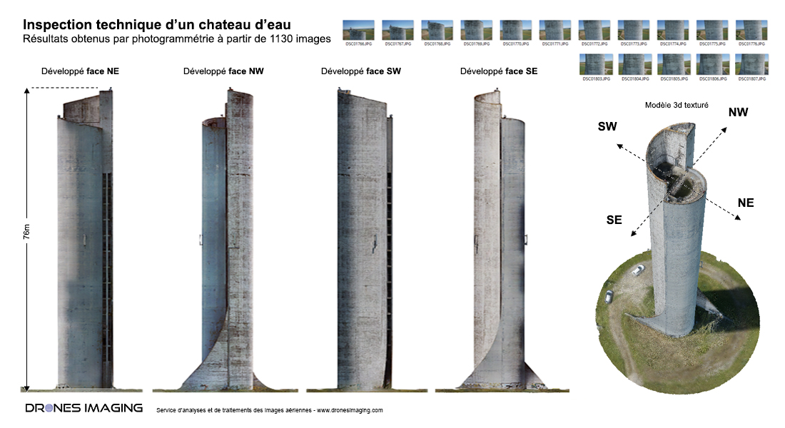
1130 aerial shots and 9 Ground Control Points (GCPs) recorded with a GNSS RTK receiver made it possible to 3D model the entire water tower in order to export 4 orthomosaics (SE, SW, NE and NW faces) with centimeter accuracy and milimeter resolution.

Digital productions thus built were delivered in vector (dense cloud) and raster (orthomosaic) form for immediate use with Autocad in order to locate all surface defects: concrete bursting, calcite, cracks, visible reinforcement and traces of rust.

TECHNICAL INFORMATIONS

  • Aerial imagery analysis & processing service : Drones Imaging company.
  • Flights and aerial imagery captation : Air City Diagnostic company.
  • Spatial accuracy : centimeter with GNSS RTK receiver.
  • Orthophoto RVB : GSD 4 mm.
  • Height of the water tower : 76m.
  • Drone : MikroKopter.
  • Camera : SONY A6000
  • Photogrammetry software : Metashape
  • Export formats : GeoTiff, Las and Dwg autocad.
  • Delivery delays : 4 days.
  • Use case taught during our Agisoft Metashape training : see more.
PrevPrécédentRoof thermal inspection and diagnostics by drone
Suivantcivil engineering structure – topographic survey of the Marly viaductNext
  • Mentions légales
  • Français
  • English