Skip to content
Services et traitements des images aériennes
Twitter Facebook Linkedin
  • Français
  • English
DRONES IMAGING
  • Drones imaging
    • Who are we
  • images processing service
    • topographic service
    • thermographic service
    • agricultural service
    • automatic counting service
    • Use case
    • Product sheets
    • useful documentation
    • download guide
  • Trainings
    • training in photogrammetry metashape option
    • training in photogrammetry Pix4D option
    • Multispectral training
    • online photogrammetry training
  • Softwares
    • Agisoft Metashape photogrammetry software
    • Undet software
  • RTK Receivers
    • EMLID GNSS RTK Reach RS3
    • EMLID GNSS RTK Reach RS2+
    • Emlid GNSS RTK Reach RX
    • EMLID GNSS RTK Reach RS+
  • Sensors
    • Agrowing Multispectral cameras
  • News
  • Contact us
  • Toggle website search
Menu Close
  • Drones imaging
    • Who are we
  • images processing service
    • topographic service
    • thermographic service
    • agricultural service
    • automatic counting service
    • Use case
    • Product sheets
    • useful documentation
    • download guide
  • Trainings
    • training in photogrammetry metashape option
    • training in photogrammetry Pix4D option
    • Multispectral training
    • online photogrammetry training
  • Softwares
    • Agisoft Metashape photogrammetry software
    • Undet software
  • RTK Receivers
    • EMLID GNSS RTK Reach RS3
    • EMLID GNSS RTK Reach RS2+
    • Emlid GNSS RTK Reach RX
    • EMLID GNSS RTK Reach RS+
  • Sensors
    • Agrowing Multispectral cameras
  • News
  • Contact us
  • Toggle website search

Blog

  1. Home>
  2. geomatics>
  3. Ben4uav & Drones Imaging support the Philippines with very high resolution imagery.

Ben4uav & Drones Imaging support the Philippines with very high resolution imagery.

  • May 29, 2014
  • 3:09 pm

Drone and humanitarian aid in the Philippines for the benefit of the Croix Rouge

Drone and humanitarian aid in the Philippines for the reconstruction of habitat and the population rehousing following Typhoon Haiyan. Realization of a high resolution orthophoto on the site of the Croix Rouge rehousing project.

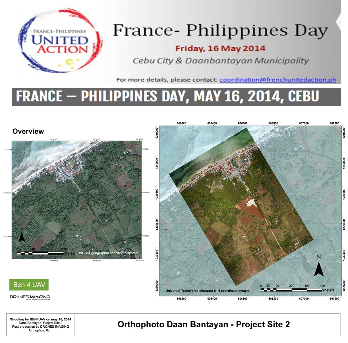
Extracts of deliverables

Drone and humanitarian aid

Friday May 16: our remote pilot partner Benoît Ribeiro on a mission to the Philippines made several photographic captures with his drones for the inauguration of a housing project undertaken by the Croix Rouge, Habitat for Humanity and French private sponsors led by France- Philippines United Action, a task force that will coordinate relief efforts over a 12-month period.

The area of operation was in the north of the island of Cebu, at two sites in Daan Bantayan commune – areas that are still under reconstruction after the devastation caused by Hurricane Haiyan.

A day later and after having received at our headquarters the 300 aerial images taken by Benoît Ribeiro, we participated in this event by generate a georeferenced orthophoto in the form of a map and a KML file easily usable in Google Earth. Above is an undersampled extract.

TECHNICAL INFORMATIONS

  • Data processing : Drones Imaging company.
  • Flights and aerial imagery : Benoît Ribeiro.
  • Spatial accuracy : decimeter.
  • Orthophoto RVB : GSD 3cm.
  • Drone fixed wing : LP960 Lehmann aviation.
  • Photogrammetry software : Metashape.
  • Exports formats : GeoTiff and Pdf.
  • Completion deadlines : 1 day.
  • Use case taught during our photogrammetry training : see more.
PrevPrécédentNDVI for estimating crop health and biomass
SuivantTerrestrial photogrammetryNext
  • Mentions légales
  • Français
  • English