Cliff survey of the Cap Champagne carried out by drone and photogrammetry - Reunion Island
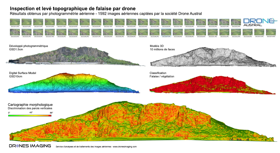
Cliff survey carried out by drone for the analysis of its stability and the study of its erosion. Results obtained from 1592 aerial shots taken by Drone Austral, a company specializing in technical inspections. Post-processing and data analysis by Drones Imaging.
Cliff inspection and 3D modeling
The office of Geological and Mining Research (BRGM, in charge of the study and monitoring of geological risks in Reunion Island) solicited the companies Drone Austral and Drones Imaging to model a cliff measuring 600m length and 100m high near the town of Cap Champagne.
With more than 200 km of coast, Reunion Island has a very diverse coastline today impacted by erosion phenomena threatening the cliffs near the roads. In this context and to anticipate landslides risks on the roads, BRGM commissioned a complete modeling of the cliff to study its least details.
Thanks to photogrammetry, 1592 aerial images taken by the company Drone Austral were used to produce a dense cloud (1pt every 10cm) allowing a very faithful 3D representation of the cliff. The 3D model thus generated and whose spatial accuracy is of the order of a few centimeters (accuracy obtained thanks to GCPs targets previously set and recorded by the GPS RTK) allowed BRGM to identify risks areas (overhanging blocks ) and to calculate volumes in case of landslides. If this 3D modeling is already an excellent support for studying the rock walls morphology, it will also serve as an initial reference to ultimately measure their evolution over time. Indeed, thanks to future aerial surveys and with detection of changes tools, it will be possible to locate and quantify automatically: the rock walls impacted and weakened by erosion.
3D visualization
TECHNICAL INFORMATIONS
- Processing and data analysis service : Drones Imaging company.
- Aerial captation : Drone Austral company.
- Spatial accuracy : centimeter.
- Orthophoto RVB : GSD 1cm.
- Drone : MikroKopter.
- Sensor : Sony A7R.
- Cliff length : 600m.
- Cliff height : 100m.
- Photogrammetry software : Metashape.
- Export formats : GeoTiff, Las and Obj.
- Delivery delay : 2 days.