Skip to content
Services et traitements des images aériennes
Twitter Facebook Linkedin
  • Français
  • English
DRONES IMAGING
  • Drones imaging
    • Who are we
  • images processing service
    • topographic service
    • thermographic service
    • agricultural service
    • automatic counting service
    • Use case
    • Product sheets
    • useful documentation
    • download guide
  • Trainings
    • training in photogrammetry metashape option
    • training in photogrammetry Pix4D option
    • Multispectral training
    • online photogrammetry training
  • Softwares
    • Agisoft Metashape photogrammetry software
    • Undet software
  • RTK Receivers
    • EMLID GNSS RTK Reach RS3
    • EMLID GNSS RTK Reach RS2+
    • Emlid GNSS RTK Reach RX
    • EMLID GNSS RTK Reach RS+
  • Sensors
    • Agrowing Multispectral cameras
  • News
  • Contact us
  • Toggle website search
Menu Close
  • Drones imaging
    • Who are we
  • images processing service
    • topographic service
    • thermographic service
    • agricultural service
    • automatic counting service
    • Use case
    • Product sheets
    • useful documentation
    • download guide
  • Trainings
    • training in photogrammetry metashape option
    • training in photogrammetry Pix4D option
    • Multispectral training
    • online photogrammetry training
  • Softwares
    • Agisoft Metashape photogrammetry software
    • Undet software
  • RTK Receivers
    • EMLID GNSS RTK Reach RS3
    • EMLID GNSS RTK Reach RS2+
    • Emlid GNSS RTK Reach RX
    • EMLID GNSS RTK Reach RS+
  • Sensors
    • Agrowing Multispectral cameras
  • News
  • Contact us
  • Toggle website search

Blog

  1. Home>
  2. geomatics>
  3. civil engineering structure – topographic survey of the Marly viaduct

civil engineering structure – topographic survey of the Marly viaduct

  • July 12, 2017
  • 1:31 am

Building Information Model of the Marly viaduct made by drone and photogrammetry

Building Information Model carried out as part of the viaduct rehabilitation works and its retaining embankments. 3D and 2D productions carried out by photogrammetry were delivered in vector form (dense cloud & textured mesh) and raster (orthomosaic) directly usable with Autocad in design office.

3D modeling by photogrammetry of the Marly viaduct

Building Information Model

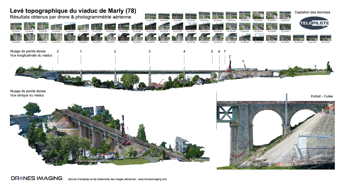
TECHNICAL INFORMATIONS

  • Post processing service : Drones Imaging company.
  • Flights and aerial imagery : Télépilote company.
  • Spatial accuracy : centimeter.
  • Viaduct length : 480m.
  • Orthophoto : GSD 7mm.
  • Drone : DJI Phantom 4.
  • Camera : FC6310.
  • Photogrammetry software : Metashape.
  • Use case taught in training : see more.
PrevPrécédentInspection of a water tower by drone & cracks detection
SuivantArchaeological detection by drone and thermal infrared.Next
  • Mentions légales
  • Français
  • English