Skip to content
Services et traitements des images aériennes
Twitter Facebook Linkedin
  • Français
  • English
DRONES IMAGING
  • Drones imaging
    • Who are we
  • images processing service
    • topographic service
    • thermographic service
    • agricultural service
    • automatic counting service
    • Use case
    • Product sheets
    • useful documentation
    • download guide
  • Trainings
    • training in photogrammetry metashape option
    • training in photogrammetry Pix4D option
    • Multispectral training
    • online photogrammetry training
  • Softwares
    • Agisoft Metashape photogrammetry software
    • Undet software
  • RTK Receivers
    • EMLID GNSS RTK Reach RS3
    • EMLID GNSS RTK Reach RS2+
    • Emlid GNSS RTK Reach RX
    • EMLID GNSS RTK Reach RS+
  • Sensors
    • Agrowing Multispectral cameras
  • News
  • Contact us
  • Toggle website search
Menu Close
  • Drones imaging
    • Who are we
  • images processing service
    • topographic service
    • thermographic service
    • agricultural service
    • automatic counting service
    • Use case
    • Product sheets
    • useful documentation
    • download guide
  • Trainings
    • training in photogrammetry metashape option
    • training in photogrammetry Pix4D option
    • Multispectral training
    • online photogrammetry training
  • Softwares
    • Agisoft Metashape photogrammetry software
    • Undet software
  • RTK Receivers
    • EMLID GNSS RTK Reach RS3
    • EMLID GNSS RTK Reach RS2+
    • Emlid GNSS RTK Reach RX
    • EMLID GNSS RTK Reach RS+
  • Sensors
    • Agrowing Multispectral cameras
  • News
  • Contact us
  • Toggle website search

Blog

  1. Home>
  2. geomatics>
  3. Terrestrial photogrammetry

Terrestrial photogrammetry

  • November 24, 2014
  • 7:58 pm

3D modeling of the Pantheon dome in Rome.

3D modeling of the Pantheon dome, masterpiece of Roman architecture. Work carried out from 800 terrestrial shots taken by Drones Imaging.

Deliverables extracts

3D textured mesh

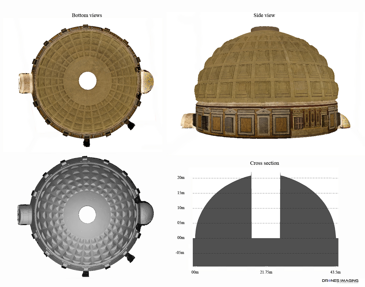
3D visualization of the Pantheon dome

Through this use case, textured mesh of the Pantheon dome (carried out by terrestrial photogrammetry), makes it possible to carry out cross sections dedicated to the geometric inspection over 360°.

TECHNICAL INFORMATIONS

  • Dta processing service : Drones Imaging comapny.
  • Terrestrial captation : Drones Imaging company.
  • Spatial accuracy : centimeter.
  • Orthophoto RVB : GSD 6mm.
  • Camera : Sony RX100 III.
  • Photogrammetry software : Metashape.
  • Export formats : GeoTiff and Obj.
  • Completion deadlines : 1 day.
  • Use case taught during our photogrammetry training : see more.
PrevPrécédentBen4uav & Drones Imaging support the Philippines with very high resolution imagery.
SuivantBulacan, Philippines – a drone for study industrial risksNext
  • Mentions légales
  • Français
  • English