Skip to content
Services et traitements des images aériennes
Twitter Facebook Linkedin
  • Français
  • English
DRONES IMAGING
  • DRONES IMAGING
    • Qui sommes-nous?
  • Services de traitement d’images
    • Service topographie
    • Service thermique
    • Service agricole
    • Service de comptage automatique
    • Cas d’usage commercialisés
    • Nos fiches produits
    • Documentation utile
    • Envoyez-nous vos images
  • Formations
    • Formation certifiante en photogrammétrie – CPF
    • Formation en photogrammétrie option metashape
    • Formation en photogrammétrie option Pix4D
    • Formation en agriculture de précision
    • Formation en ligne
    • Planning formations
  • Logiciels
    • Logiciel Agisoft Metashape
    • Logiciel Undet
  • Récepteurs RTK
    • Récepteur GNSS RTK Emlid Reach RS3
    • Récepteur GNSS RTK Emlid Reach RS2+
    • Récepteur GNSS RTK Emlid Reach RX
    • Récepteur GNSS RTK Emlid Reach RS+
    • Abonnements Orphéon
    • Stations électriques Ecoflow
  • Capteurs
    • Caméras multispectrales Agrowing
  • News
  • Contact
  • Toggle website search
Menu Fermer
  • DRONES IMAGING
    • Qui sommes-nous?
  • Services de traitement d’images
    • Service topographie
    • Service thermique
    • Service agricole
    • Service de comptage automatique
    • Cas d’usage commercialisés
    • Nos fiches produits
    • Documentation utile
    • Envoyez-nous vos images
  • Formations
    • Formation certifiante en photogrammétrie – CPF
    • Formation en photogrammétrie option metashape
    • Formation en photogrammétrie option Pix4D
    • Formation en agriculture de précision
    • Formation en ligne
    • Planning formations
  • Logiciels
    • Logiciel Agisoft Metashape
    • Logiciel Undet
  • Récepteurs RTK
    • Récepteur GNSS RTK Emlid Reach RS3
    • Récepteur GNSS RTK Emlid Reach RS2+
    • Récepteur GNSS RTK Emlid Reach RX
    • Récepteur GNSS RTK Emlid Reach RS+
    • Abonnements Orphéon
    • Stations électriques Ecoflow
  • Capteurs
    • Caméras multispectrales Agrowing
  • News
  • Contact
  • Toggle website search

Blog

  1. Accueil>
  2. Réalisations>
  3. Levé topographique réalisé à partir d’imagerie open source.

Levé topographique réalisé à partir d’imagerie open source.

  • juin 24, 2016
  • 7:20 pm

Modélisation 3D open source.

Modélisation 3D open source: levé topographique & modélisation 3D de Castle Island réalisés à partir d’imagerie satellite à partir de Google Earth.

Modélisation 3D de Castle Island

Modélisation 3D open source

Visualisation 3D de Castle Island

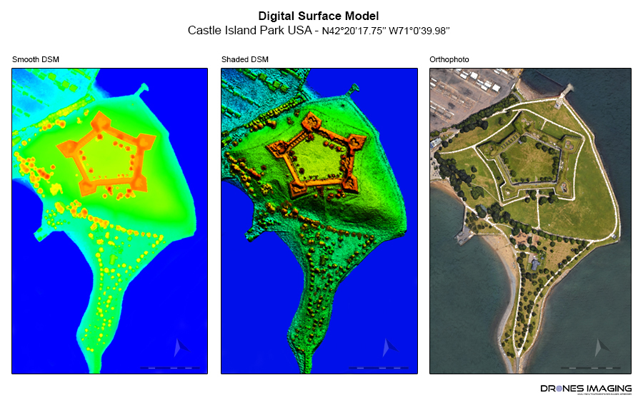
Castle Island est une ancienne ile rattachée au continent américain depuis 1928. Située sur le Day Boulevard au Sud de Boston, elle fut l’objet d’une fortification en étoile en 1634.

INFORMATIONS TECHNIQUES

  • Service de traitement d’images : société Drones Imaging.
  • Imagerie aérienne : Google Earth.
  • Précision spatiale : métrique.
  • Vecteur aérien : satellite.
  • Logiciel de photogrammétrie : Agisoft Metashape.
  • Délai de réalisation : 02h30.
  • Cas d’usage enseigné durant notre formation en photogrammétrie : voir plus.
PrécédentPrécédentPlan topographique & volumétrie réalisés par photogrammétrie aérienne.
SuivantFormation au télépilotage appliqué à la photogrammétrie: inspection de façadeSuivant
  • Mentions légales
  • Français
  • English
Copyright 2025 - Drones Imaging