Skip to content
Services et traitements des images aériennes
Twitter Facebook Linkedin
  • Français
  • English
DRONES IMAGING
  • DRONES IMAGING
    • Qui sommes-nous?
  • Services de traitement d’images
    • Service topographie
    • Service thermique
    • Service agricole
    • Service de comptage automatique
    • Cas d’usage commercialisés
    • Nos fiches produits
    • Documentation utile
    • Envoyez-nous vos images
  • Formations
    • Formation certifiante en photogrammétrie – CPF
    • Formation en photogrammétrie option metashape
    • Formation en photogrammétrie option Pix4D
    • Formation en agriculture de précision
    • Formation en ligne
    • Planning formations
  • Logiciels
    • Logiciel Agisoft Metashape
    • Logiciel Reality Capture
    • Logiciel Undet
  • Récepteurs RTK
    • Récepteur GNSS RTK Emlid Reach RS2+
    • Récepteur GNSS RTK Emlid Reach RX
    • Récepteur GNSS RTK Emlid Reach RS+
    • Abonnements Orphéon
    • Stations électriques Ecoflow
  • Capteurs
    • Caméras multispectrales Agrowing
  • News
  • Contact
Menu Fermer
  • DRONES IMAGING
    • Qui sommes-nous?
  • Services de traitement d’images
    • Service topographie
    • Service thermique
    • Service agricole
    • Service de comptage automatique
    • Cas d’usage commercialisés
    • Nos fiches produits
    • Documentation utile
    • Envoyez-nous vos images
  • Formations
    • Formation certifiante en photogrammétrie – CPF
    • Formation en photogrammétrie option metashape
    • Formation en photogrammétrie option Pix4D
    • Formation en agriculture de précision
    • Formation en ligne
    • Planning formations
  • Logiciels
    • Logiciel Agisoft Metashape
    • Logiciel Reality Capture
    • Logiciel Undet
  • Récepteurs RTK
    • Récepteur GNSS RTK Emlid Reach RS2+
    • Récepteur GNSS RTK Emlid Reach RX
    • Récepteur GNSS RTK Emlid Reach RS+
    • Abonnements Orphéon
    • Stations électriques Ecoflow
  • Capteurs
    • Caméras multispectrales Agrowing
  • News
  • Contact

Blog

Accueil » Actualités » Activité végétale: NDVI.

Activité végétale: NDVI.

  • mars 30, 2014
  • 6:27

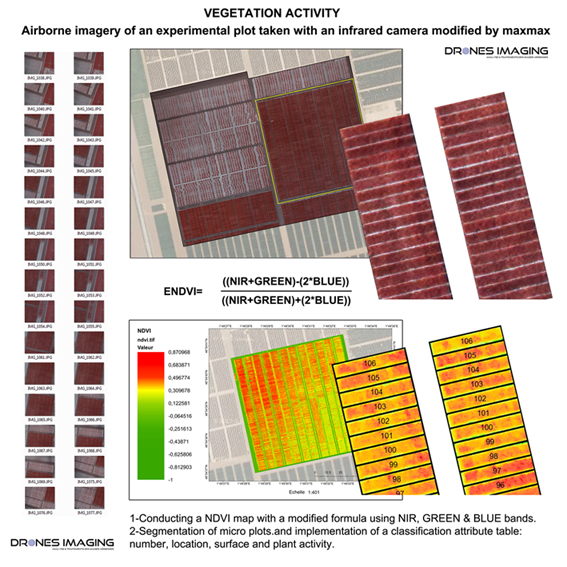
Captation aérienne réalisée sur une parcelle agricole expérimentale avec un appareil photo infrarouge.

1-Réalisation d’une carte NDVI avec une formule modifiée utilisant les canaux PIR, VERT & BLEU.

2-Segmentation des micro parcelles et implémentation de valeurs attributaires telles que: le numéro de parcelle, sa localisation géographique, sa surface et sa vigueur végétale.

Plate forme: Drone hexacoptère
Camera: CANON SX260HS
Orthomosaic: résolution 5 cm
Date: 28 mars 2014

ndvi_experimental_plot_EN

Airborne imagery and processing performed on an experimental plot with an infrared camera modified by maxmax.

1-Conducting a NDVI map with a modified formula using NIR, GREEN & BLUE channels.

2-Segmentation of micro plots and implementation of a classification attribute table: number, location, surface and plant activity.

Air vector: Drone hexacopter
Camera: CANON SX260HS
Orthomosaic: resolution 5 cm
Date: 28 march 2014

ndvi_experimental_plot_EN

PrécédentPrécédentMODELISATION 3D des remparts de Ston.
SuivantBen4uav & Drones Imaging soutiennent les Philippines avec de l’imagerie à très haute résolution.Suivant
  • Mentions légales
  • FrançaisFrançais
  • EnglishEnglish
Copyright 2023 - Drones Imaging