Skip to content
Services et traitements des images aériennes
Twitter Facebook Linkedin
  • Français
  • English
DRONES IMAGING
  • DRONES IMAGING
    • Qui sommes-nous?
  • Services de traitement d’images
    • Service topographie
    • Service thermique
    • Service agricole
    • Service de comptage automatique
    • Cas d’usage commercialisés
    • Nos fiches produits
    • Documentation utile
    • Envoyez-nous vos images
  • Formations
    • Formation certifiante en photogrammétrie – CPF
    • Formation en photogrammétrie option metashape
    • Formation en photogrammétrie option Pix4D
    • Formation en agriculture de précision
    • Formation en ligne
    • Planning formations
  • Logiciels
    • Logiciel Agisoft Metashape
    • Logiciel Undet
  • Récepteurs RTK
    • Récepteur GNSS RTK Emlid Reach RS3
    • Récepteur GNSS RTK Emlid Reach RS2+
    • Récepteur GNSS RTK Emlid Reach RX
    • Récepteur GNSS RTK Emlid Reach RS+
    • Abonnements Orphéon
    • Stations électriques Ecoflow
  • Capteurs
    • Caméras multispectrales Agrowing
  • News
  • Contact
  • Toggle website search
Menu Fermer
  • DRONES IMAGING
    • Qui sommes-nous?
  • Services de traitement d’images
    • Service topographie
    • Service thermique
    • Service agricole
    • Service de comptage automatique
    • Cas d’usage commercialisés
    • Nos fiches produits
    • Documentation utile
    • Envoyez-nous vos images
  • Formations
    • Formation certifiante en photogrammétrie – CPF
    • Formation en photogrammétrie option metashape
    • Formation en photogrammétrie option Pix4D
    • Formation en agriculture de précision
    • Formation en ligne
    • Planning formations
  • Logiciels
    • Logiciel Agisoft Metashape
    • Logiciel Undet
  • Récepteurs RTK
    • Récepteur GNSS RTK Emlid Reach RS3
    • Récepteur GNSS RTK Emlid Reach RS2+
    • Récepteur GNSS RTK Emlid Reach RX
    • Récepteur GNSS RTK Emlid Reach RS+
    • Abonnements Orphéon
    • Stations électriques Ecoflow
  • Capteurs
    • Caméras multispectrales Agrowing
  • News
  • Contact
  • Toggle website search

Blog

  1. Accueil>
  2. Réalisations>
  3. Inspection d’ouvrage d’art – modélisation d’une travée de pont.

Inspection d’ouvrage d’art – modélisation d’une travée de pont.

  • octobre 8, 2013
  • 12:54 pm

Captation photographique réalisée par la société Next Generation Vision / post processing par Drones Imaging. Ile de france: la reconstruction 3D d’une travée de pont (ligne RER A) a permis d’inspecter l’état structurel du béton.

Plate forme: Drone hexacoptère
Caméra: SONY NEX7 24 Mégapixels
Orthomosaïque: résolution 1 mm
Localisation: Nanterre
Date: 04 octobre 2013

inspection_pont_dronesimaging

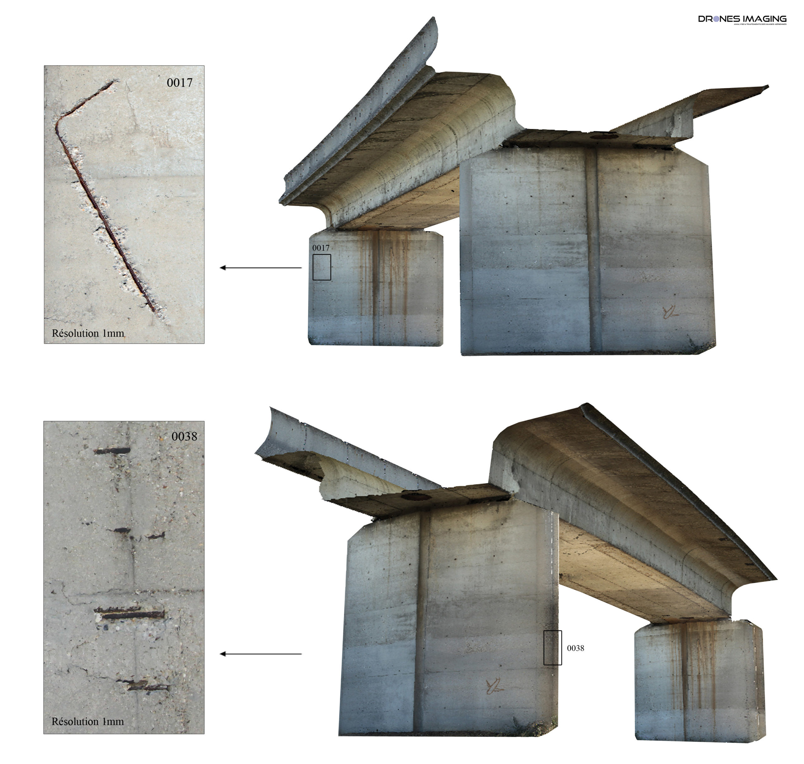
Photographic capture performed by the company Next Generation Vision / post processing par Drones Imaging. Ile de France: 3D reconstruction of a bridge span (RER line A) was used to inspect the structural condition of the concrete.

Vector: hexacopter
Camera: SONY NEX7 24 Megapixels
Orthomosaic: resolution 1 mm
Location: Nanterre
Date: 04 october 2013

inspection_pont_dronesimaging

PrécédentPrécédentModélisation 3D et développé photogrammétrique du pont de Mostar.
SuivantMODELISATION 3D des remparts de Ston.Suivant
  • Mentions légales
  • Français
  • English
Copyright 2025 - Drones Imaging