Skip to content
Services et traitements des images aériennes
Twitter Facebook Linkedin
  • Français
  • English
DRONES IMAGING
  • DRONES IMAGING
    • Qui sommes-nous?
  • Services de traitement d’images
    • Service topographie
    • Service thermique
    • Service agricole
    • Service de comptage automatique
    • Cas d’usage commercialisés
    • Nos fiches produits
    • Documentation utile
    • Envoyez-nous vos images
  • Formations
    • Formation certifiante en photogrammétrie – CPF
    • Formation en photogrammétrie option metashape
    • Formation en photogrammétrie option Pix4D
    • Formation en agriculture de précision
    • Formation en ligne
    • Planning formations
  • Logiciels
    • Logiciel Agisoft Metashape
    • Logiciel Undet
  • Récepteurs RTK
    • Récepteur GNSS RTK Emlid Reach RS3
    • Récepteur GNSS RTK Emlid Reach RS2+
    • Récepteur GNSS RTK Emlid Reach RX
    • Récepteur GNSS RTK Emlid Reach RS+
    • Abonnements Orphéon
    • Stations électriques Ecoflow
  • Capteurs
    • Caméras multispectrales Agrowing
  • News
  • Contact
  • Toggle website search
Menu Fermer
  • DRONES IMAGING
    • Qui sommes-nous?
  • Services de traitement d’images
    • Service topographie
    • Service thermique
    • Service agricole
    • Service de comptage automatique
    • Cas d’usage commercialisés
    • Nos fiches produits
    • Documentation utile
    • Envoyez-nous vos images
  • Formations
    • Formation certifiante en photogrammétrie – CPF
    • Formation en photogrammétrie option metashape
    • Formation en photogrammétrie option Pix4D
    • Formation en agriculture de précision
    • Formation en ligne
    • Planning formations
  • Logiciels
    • Logiciel Agisoft Metashape
    • Logiciel Undet
  • Récepteurs RTK
    • Récepteur GNSS RTK Emlid Reach RS3
    • Récepteur GNSS RTK Emlid Reach RS2+
    • Récepteur GNSS RTK Emlid Reach RX
    • Récepteur GNSS RTK Emlid Reach RS+
    • Abonnements Orphéon
    • Stations électriques Ecoflow
  • Capteurs
    • Caméras multispectrales Agrowing
  • News
  • Contact
  • Toggle website search

Blog

  1. Accueil>
  2. Réalisations>
  3. Activité végétale: NDVI.

Activité végétale: NDVI.

  • mars 30, 2014
  • 6:27 pm

Indice de végétation NDVI

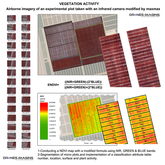
Indice de végétation NDVI: captation aérienne réalisée sur une parcelle agricole expérimentale avec un appareil photo infrarouge. Réalisation d’une carte NDVI avec une formule modifiée utilisant les canaux PIR, VERT & BLEU. Segmentation et classification par la suite des micro parcelles avec implémentation de valeurs attributaires telles que: le numéro de parcelle, sa localisation géographique, sa surface et sa vigueur végétale selon l’indice NDVI calculé.

Orthophoto proche infrarouge et NDVI

Indice de végétation NDVI

INFORMATIONS TECHNIQUES

  • Service de traitement d’images multispectrales : société Drones Imaging.
  • Captation aérienne : société Azur drones.
  • Précision spatiale : métrique avec la BD Ortho de l’IGN et centimétrique en relatif.
  • Surface totale analysée : 08ha.
  • Vecteur aérien : Drone Hexacoptère.
  • Capteur multispectral : CANON SX260HS MaxMax.
  • Logiciel de photogrammétrie : Agisoft Metashape.
  • Système d’Information Géographique : Arcgis.
  • Formats d’export : GeoTiff, Shp, Xls et Kmz.
  • Délais de réalisation : 2 jours.
PrécédentPrécédentMODELISATION 3D des remparts de Ston.
SuivantBen4uav & Drones Imaging soutiennent les Philippines avec de l’imagerie à très haute résolution.Suivant
  • Mentions légales
  • Français
  • English
Copyright 2025 - Drones Imaging