Skip to content
Services et traitements des images aériennes
Twitter Facebook Linkedin
  • Français
  • English
DRONES IMAGING
  • DRONES IMAGING
    • Qui sommes-nous?
  • Services de traitement d’images
    • Service topographie
    • Service thermique
    • Service agricole
    • Service de comptage automatique
    • Cas d’usage commercialisés
    • Nos fiches produits
    • Documentation utile
    • Envoyez-nous vos images
  • Formations
    • Formation certifiante en photogrammétrie – CPF
    • Formation en photogrammétrie option metashape
    • Formation en photogrammétrie option Pix4D
    • Formation en agriculture de précision
    • Formation en ligne
    • Planning formations
  • Logiciels
    • Logiciel Agisoft Metashape
    • Logiciel Reality Capture
    • Logiciel Undet
  • Récepteurs RTK
    • Récepteur GNSS RTK Emlid Reach RS2+
    • Récepteur GNSS RTK Emlid Reach RX
    • Récepteur GNSS RTK Emlid Reach RS+
    • Abonnements Orphéon
    • Stations électriques Ecoflow
  • Capteurs
    • Caméras multispectrales Agrowing
  • News
  • Contact
Menu Fermer
  • DRONES IMAGING
    • Qui sommes-nous?
  • Services de traitement d’images
    • Service topographie
    • Service thermique
    • Service agricole
    • Service de comptage automatique
    • Cas d’usage commercialisés
    • Nos fiches produits
    • Documentation utile
    • Envoyez-nous vos images
  • Formations
    • Formation certifiante en photogrammétrie – CPF
    • Formation en photogrammétrie option metashape
    • Formation en photogrammétrie option Pix4D
    • Formation en agriculture de précision
    • Formation en ligne
    • Planning formations
  • Logiciels
    • Logiciel Agisoft Metashape
    • Logiciel Reality Capture
    • Logiciel Undet
  • Récepteurs RTK
    • Récepteur GNSS RTK Emlid Reach RS2+
    • Récepteur GNSS RTK Emlid Reach RX
    • Récepteur GNSS RTK Emlid Reach RS+
    • Abonnements Orphéon
    • Stations électriques Ecoflow
  • Capteurs
    • Caméras multispectrales Agrowing
  • News
  • Contact

Archives quotidiennes : 11 avril 2016

Accueil » Actualités 11 avril 2016
plan exploitation carrière

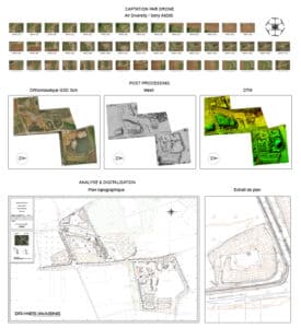
Levé topographique et plan réglementaire de carrière.

  • Réalisations
  • avril 11, 2016
Plan topographique réglementaire réalisé par photogrammétrie à partir d’images aériennes. Plan topographique réglementaire au format Autocad sur une carrière
Continuer la lecture
  • Mentions légales
  • FrançaisFrançais
  • EnglishEnglish
Copyright 2023 - Drones Imaging