Skip to content
Services et traitements des images aériennes
Twitter Facebook Linkedin
  • Français
  • English
DRONES IMAGING
  • DRONES IMAGING
    • Qui sommes-nous?
  • Services de traitement d’images
    • Service topographie
    • Service thermique
    • Service agricole
    • Service de comptage automatique
    • Cas d’usage commercialisés
    • Nos fiches produits
    • Documentation utile
    • Envoyez-nous vos images
  • Formations
    • Formation certifiante en photogrammétrie – CPF
    • Formation en photogrammétrie option metashape
    • Formation en photogrammétrie option Pix4D
    • Formation en agriculture de précision
    • Formation en ligne
    • Planning formations
  • Logiciels
    • Logiciel Agisoft Metashape
    • Logiciel Undet
  • Récepteurs RTK
    • Récepteur GNSS RTK Emlid Reach RS3
    • Récepteur GNSS RTK Emlid Reach RS2+
    • Récepteur GNSS RTK Emlid Reach RX
    • Récepteur GNSS RTK Emlid Reach RS+
    • Abonnements Orphéon
    • Stations électriques Ecoflow
  • Capteurs
    • Caméras multispectrales Agrowing
  • News
  • Contact
  • Toggle website search
Menu Fermer
  • DRONES IMAGING
    • Qui sommes-nous?
  • Services de traitement d’images
    • Service topographie
    • Service thermique
    • Service agricole
    • Service de comptage automatique
    • Cas d’usage commercialisés
    • Nos fiches produits
    • Documentation utile
    • Envoyez-nous vos images
  • Formations
    • Formation certifiante en photogrammétrie – CPF
    • Formation en photogrammétrie option metashape
    • Formation en photogrammétrie option Pix4D
    • Formation en agriculture de précision
    • Formation en ligne
    • Planning formations
  • Logiciels
    • Logiciel Agisoft Metashape
    • Logiciel Undet
  • Récepteurs RTK
    • Récepteur GNSS RTK Emlid Reach RS3
    • Récepteur GNSS RTK Emlid Reach RS2+
    • Récepteur GNSS RTK Emlid Reach RX
    • Récepteur GNSS RTK Emlid Reach RS+
    • Abonnements Orphéon
    • Stations électriques Ecoflow
  • Capteurs
    • Caméras multispectrales Agrowing
  • News
  • Contact
  • Toggle website search

Blog

  1. Accueil>
  2. Réalisations>
  3. MODELISATION 3D des remparts de Ston.

MODELISATION 3D des remparts de Ston.

  • janvier 2, 2014
  • 8:39 pm

Captation photographique réalisée par la société Next Generation Vision / post processing par Drones Imaging.

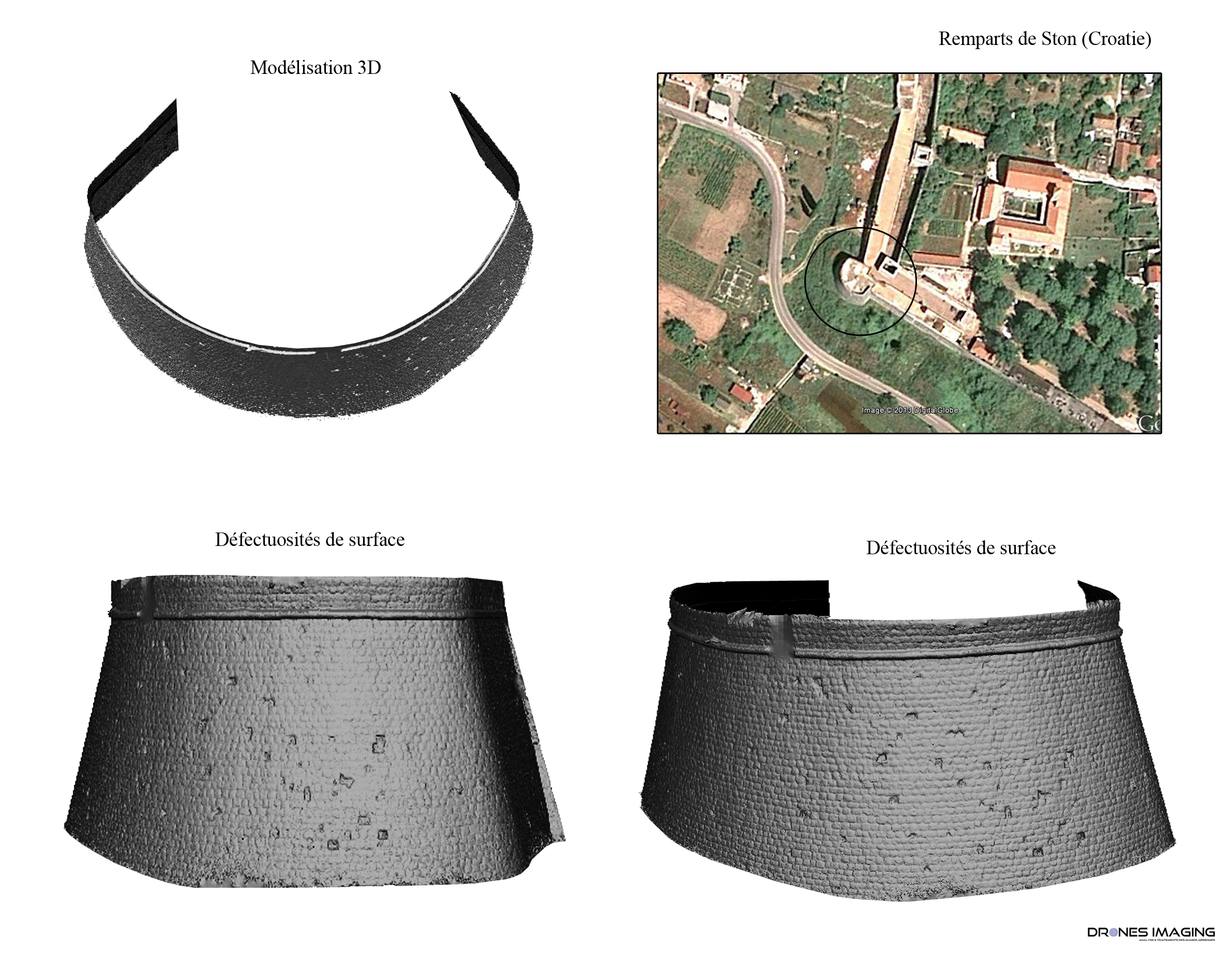
Croatie: la reconstruction 3D d’une partie des remparts de Ston a permis d’inspecter l’état structurel de la maçonnerie. Une carte des pierres manquantes fut réalisée ensuite sur le développé photogrammétrique.

Plate forme: Drone hexacoptère
Caméra: SONY NEX7 24 Mégapixels
Orthomosaïque: résolution 1 mm
Localisation: Ston
Date: 20 décembre 2013

modelisation_rempart_dronesimaging

Photographic capture performed by the company Next Generation Vision / post processing by Drones Imaging.

Croatia: 3D reconstruction of part of the walls of Ston allowed to inspect the structural condition of the masonry. A map of the missing stone was set on a photogrammetric developed.

Vector: hexacopter
Camera: SONY NEX7 24 Megapixels
Orthomosaic: resolution 1 mm
Location: Ston
Date: 20 december 2013

modelisation_rempart_dronesimaging

PrécédentPrécédentInspection d’ouvrage d’art – modélisation d’une travée de pont.
SuivantActivité végétale: NDVI.Suivant
  • Mentions légales
  • Français
  • English
Copyright 2025 - Drones Imaging